Stampa:Map administrative divisions of the First French Empire 1812-en.svg

Fajl oriġinali (Fajl fil-format SVG, dimensjoni nominali 2,052 × 1,728 pixel, dimensjoni tal-fajl: 3.86 MB)
| Dan huwa fajl mill-Wikimedia Commons. Il-deskrizzjoni fuq il-paġna ta' diskussjoni oriġinali tidher hawn taħt.
|
Taqsira
| Deskrizzjoni |
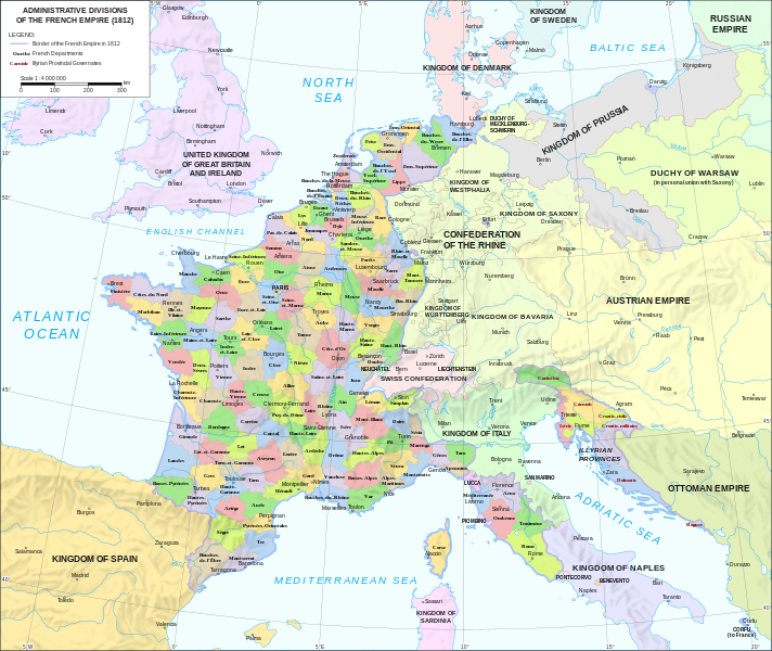
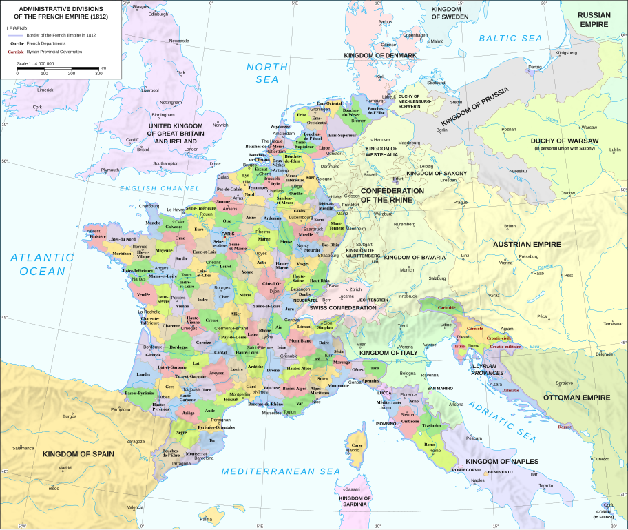
Català: Divisions administratives del Primer Imperi Francès el 1812
English: Administrative divisions of the First French Empire in 1812 |
| Data | |
| Sors |
|
| Awtur | Andrein |
| Verżjonijiet oħra |
Other related versions:[]
|


|
This SVG file contains embedded text that can be translated into your language, using any capable SVG editor, text editor or the SVG Translate tool. For more information see: About translating SVG files. |
This file is translated using SVG <switch> elements. All translations are stored in the same file! Learn more.
For most Wikipedia projects, you can embed the file normally (without a To translate the text into your language, you can use the SVG Translate tool. Alternatively, you can download the file to your computer, add your translations using whatever software you're familiar with, and re-upload it with the same name. You will find help in Graphics Lab if you're not sure how to do this. |
Liċenzja
- Inti ħieles:
- li taqsam – li tikkopja, tiddistribwixxi u tittrażmetti din l-opra
- li timmodifika – li tadatta l-biċċa xogħol
- Taħt il-kundizzjonijiet segwenti:
- attribuzzjoni – Għandek tattribwixxi x-xogħol bil-mod speċifikat mill-awtur jew minn min ta l-l-iċenzja (imma mhux b'xi mod li jissuġġerixxi ji jappoġjaw lilek jew l-użu tax-xogħol).
- Ixxerja bl-istess mod – Jekk tbiddel, tittrasforma jew tibni fuq dan il-materjal, inti għandek bżonn taqsam il-kontribuzzjonijiet tiegħek taħt l-istess liċenzja jew waħda li taqbel ma' dik oriġinali.
Kronoloġija tal-fajl
Agħfas fuq il-grupp data/ħin biex tara l-fajl biex tara kif jidher dak il-ħin.
| Data/Ħin | Minjatura | Qisien | Utent | Kumment | |
|---|---|---|---|---|---|
| kurrenti | 12:33, 9 Frar 2024 | | 2,052 × 1,728 (3.86 MB) | Manlleus | added catalan language |
| 17:10, 21 Mejju 2021 |  | 2,052 × 1,728 (3.55 MB) | Andrei Stroe | File uploaded using svgtranslate tool (https://svgtranslate.toolforge.org/). Added translation for ro. | |
| 12:32, 30 Awwissu 2020 |  | 2,052 × 1,728 (3.24 MB) | Jfblanc | File uploaded using svgtranslate tool (https://svgtranslate.toolforge.org/). Added translation for oc. | |
| 10:37, 1 Marzu 2018 |  | 2,052 × 1,728 (2.83 MB) | Imperator Honorius | Formatting Fix | |
| 10:29, 1 Marzu 2018 |  | 2,052 × 1,728 (2.83 MB) | Imperator Honorius | Formatting and missing Anglicization (Gand to Ghent) | |
| 10:17, 1 Marzu 2018 |  | 2,052 × 1,728 (2.83 MB) | Imperator Honorius | Spelling and typos; more Anglicised (and up to date) city names. | |
| 19:41, 20 Lulju 2015 |  | 2,052 × 1,728 (2.82 MB) | ArdadN | spelling | |
| 17:11, 20 Lulju 2015 |  | 2,052 × 1,728 (2.81 MB) | ArdadN | 1 | |
| 17:05, 20 Lulju 2015 |  | 2,052 × 1,728 (2.81 MB) | ArdadN | font size | |
| 16:06, 20 Lulju 2015 |  | 2,052 × 1,728 (2.81 MB) | ArdadN | 1 |
Użu tal-fajl
Il-Paġna segwenti twassal għal din l-istampa:
L-użu globali tal-fajl
Il-wikis segwenti jużaw dan il-fajl:
- Użu fuq af.wikipedia.org
- Użu fuq ar.wikipedia.org
- Użu fuq ca.wikipedia.org
- Użu fuq en.wikipedia.org
- History of the Netherlands
- 1810s
- Departments of France
- 130 departments of the First French Empire
- Illyrian Provinces
- Kingdom of Italy (Napoleonic)
- Portal:Maps/Maps/Political
- Portal:Maps/Maps/Political/14
- First French Empire
- Bouches-del'Èbre
- Department of Segre
- Left Bank of the Rhine
- User:Falcaorib
- User:Dakaysaa/sandbox
- Użu fuq et.wikipedia.org
- Użu fuq fr.wikipedia.org
- Użu fuq hr.wikipedia.org
- Użu fuq it.wikipedia.org
- Użu fuq ka.wikipedia.org
- Użu fuq km.wikipedia.org
- Użu fuq no.wikipedia.org
- Użu fuq pl.wikipedia.org
- Użu fuq pnb.wikipedia.org
- Użu fuq pt.wikipedia.org
- Użu fuq ru.wikipedia.org
- Użu fuq tr.wikipedia.org
- Użu fuq ur.wikipedia.org
- Użu fuq vi.wikipedia.org