Stampa:Iraq marshes 1994.jpg

Daqs tad-dehra proviżorja: 600 × 600 pixels. Riżoluzzjonijiet oħra: 240 × 240 pixels | 480 × 480 pixels | 768 × 768 pixels | 1,024 × 1,024 pixels | 1,296 × 1,296 pixels
Fajl oriġinali (1,296 × 1,296 pixel, dimensjoni: 215 KB, tip ta' MIME: image/jpeg)
| Dan huwa fajl mill-Wikimedia Commons. Il-deskrizzjoni fuq il-paġna ta' diskussjoni oriġinali tidher hawn taħt.
|

|
This geology image could be re-created using vector graphics as an SVG file. This has several advantages; see Commons:Media for cleanup for more information. If an SVG form of this image is available, please upload it and afterwards replace this template with
{{vector version available|new image name}}.
It is recommended to name the SVG file “Iraq marshes 1994.svg”—then the template Vector version available (or Vva) does not need the new image name parameter. |


Taqsira
| Deskrizzjoni |
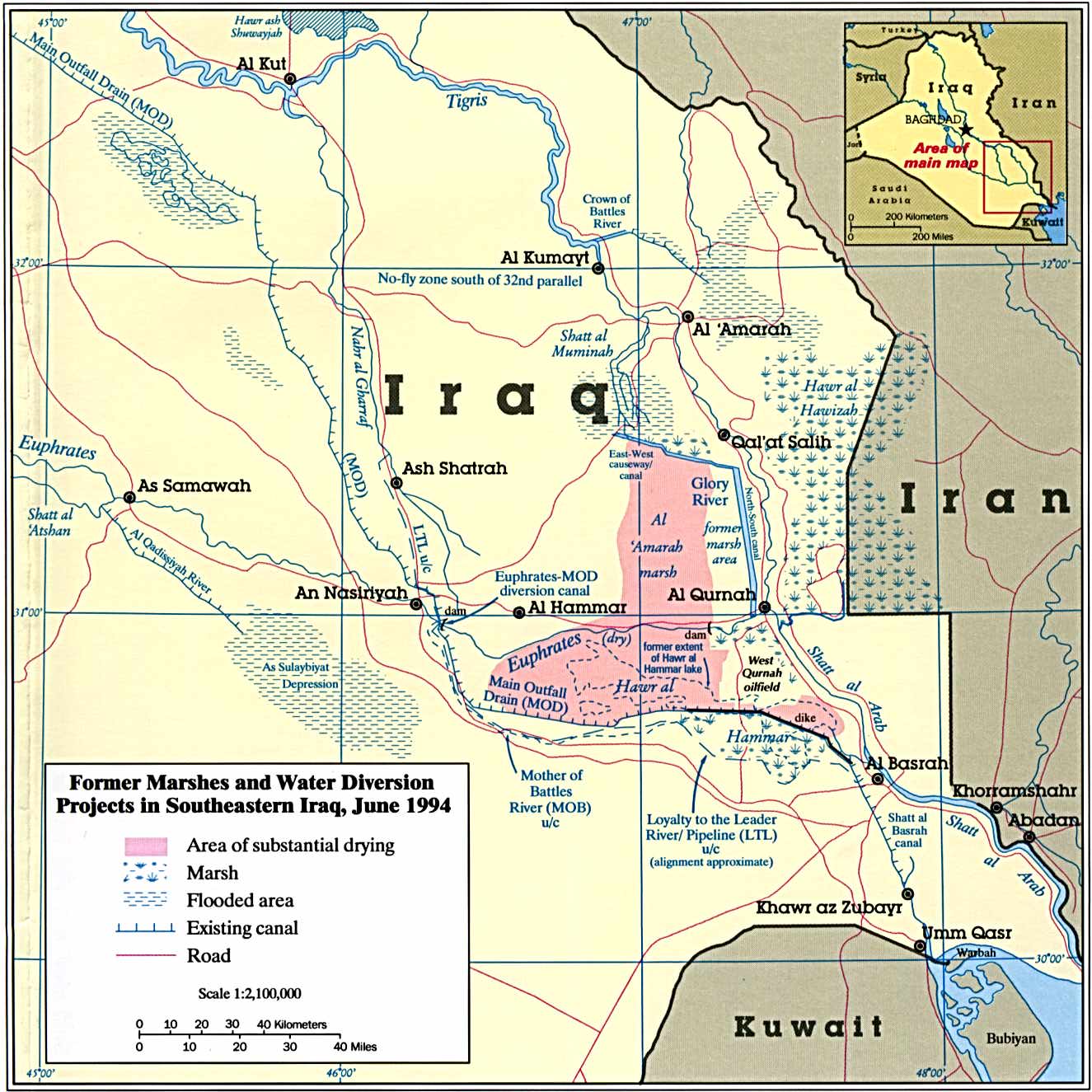
English: Iraq - Marshes - Former Marshes and Water Diversion Projects in Southeastern Iraq |
| Data | |
| Sors | http://www.mapcruzin.com/free-iraq-maps.htm direct link |
| Awtur | Central Intelligence Agency - The Destruction of Iraq's Southern Marshes, CIA Publication IA 94-10020 |
Liċenzja
This work is in the public domain in the United States because it is a work prepared by an officer or employee of the United States Government as part of that person’s official duties under the terms of Title 17, Chapter 1, Section 105 of the US Code.
Note: This only applies to original works of the Federal Government and not to the work of any individual U.S. state, territory, commonwealth, county, municipality, or any other subdivision. This template also does not apply to postage stamp designs published by the United States Postal Service since 1978. (See § 313.6(C)(1) of Compendium of U.S. Copyright Office Practices). It also does not apply to certain US coins; see The US Mint Terms of Use.
|
 | |
| This file has been identified as being free of known restrictions under copyright law, including all related and neighboring rights. | ||
Kronoloġija tal-fajl
Agħfas fuq il-grupp data/ħin biex tara l-fajl biex tara kif jidher dak il-ħin.
| Data/Ħin | Minjatura | Qisien | Utent | Kumment | |
|---|---|---|---|---|---|
| kurrenti | 16:23, 5 Ġunju 2011 | | 1,296 × 1,296 (215 KB) | Ras67 | losslessly cropped with Jpegcrop |
| 00:40, 12 Diċembru 2009 |  | 1,325 × 1,325 (238 KB) | Sanorton | {{Information |Description={{en|1=Iraq - Marshes - Former Marshes and Water Diversion Projects in Southeastern Iraq}} |Source=http://www.mapcruzin.com/free-maps-iraq/iraq_marshes_1994.jpg |Author=Central Intelligence Agency |Date=19940601 |Permission= |ot |
Użu tal-fajl
Il-Paġna segwenti twassal għal din l-istampa:
L-użu globali tal-fajl
Il-wikis segwenti jużaw dan il-fajl:
- Użu fuq ar.wikipedia.org
- Użu fuq azb.wikipedia.org
- Użu fuq de.wikipedia.org
- Użu fuq en.wikipedia.org
- Użu fuq en.wikivoyage.org
- Użu fuq es.wikipedia.org
- Użu fuq fa.wikipedia.org
- Użu fuq fr.wikipedia.org
- Użu fuq hr.wikipedia.org
- Użu fuq hy.wikipedia.org
- Użu fuq it.wikipedia.org
- Użu fuq nn.wikipedia.org
- Użu fuq pt.wikipedia.org
- Użu fuq ru.wikipedia.org
- Użu fuq tr.wikipedia.org
- Użu fuq uk.wikipedia.org
- Użu fuq uz.wikipedia.org
- Użu fuq www.wikidata.org
- Użu fuq zh.wikipedia.org