Stampa:France departments 1791 (1).jpg

Fajl oriġinali (1,635 × 1,303 pixel, dimensjoni: 895 KB, tip ta' MIME: image/jpeg)
| Dan huwa fajl mill-Wikimedia Commons. Il-deskrizzjoni fuq il-paġna ta' diskussjoni oriġinali tidher hawn taħt.
|
.jpg)
| Deskrizzjoni |
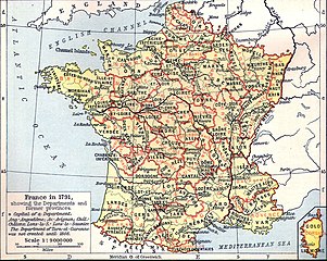
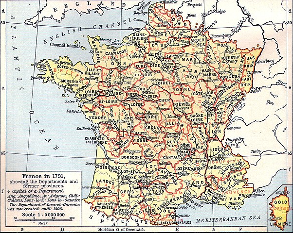
Français : Carte de la France en 1791 (départements et anciennes provinces - en rouge) in The Historical Atlas by William R. Shepherd, 1926
Lëtzebuergesch: Departementer vu Frankräich am Joer 1791. |
| Data | 11 Marzu 2006 (original upload date) |
| Sors | Transferred from fr.wikipedia to Commons by Korrigan using CommonsHelper. |
| Awtur | The original uploader was Tournachon at Franċiż Wikipedija. |
| Verżjonijiet oħra | Derivative works of this file: Départements et provinces de France.png |
Liċenzja
|
This work is in the public domain in its country of origin and other countries and areas where the copyright term is the author's life plus 70 years or fewer.
| |
| This file has been identified as being free of known restrictions under copyright law, including all related and neighboring rights. | |
Original upload log
- 2006-03-11 14:51 Tournachon 741×599×??? (225908 bytes)
Kronoloġija tal-fajl
Agħfas fuq il-grupp data/ħin biex tara l-fajl biex tara kif jidher dak il-ħin.
| Data/Ħin | Minjatura | Qisien | Utent | Kumment | |
|---|---|---|---|---|---|
| kurrenti | 14:31, 22 Lulju 2022 | | 1,635 × 1,303 (895 KB) | Hohum | Clearer version |
| 22:43, 24 Jannar 2012 |  | 741 × 599 (634 KB) | MarcusBritish | Lower red tint. | |
| 22:41, 24 Jannar 2012 |  | 741 × 599 (622 KB) | MarcusBritish | Improve tones/colour/contrast. | |
| 08:46, 22 Settembru 2008 |  | 741 × 599 (221 KB) | File Upload Bot (Magnus Manske) | {{BotMoveToCommons|fr.wikipedia}} {{Information |Description={{fr|Carte de la France en 1791 (départements et anciennes provinces - en rouge) in The Historical Atlas by William R. Shepherd, 1926 == Licence == [[:fr:Catégorie:Cartes Histoire de Fr |
Użu tal-fajl
Il-Paġna segwenti twassal għal din l-istampa:
L-użu globali tal-fajl
Il-wikis segwenti jużaw dan il-fajl:
- Użu fuq als.wikipedia.org
- Użu fuq br.wikipedia.org
- Użu fuq de.wikipedia.org
- Użu fuq el.wikipedia.org
- Użu fuq eo.wikipedia.org
- Użu fuq es.wikipedia.org
- Użu fuq eu.wikipedia.org
- Użu fuq fi.wikipedia.org
- Użu fuq fr.wikipedia.org
- Użu fuq hu.wikipedia.org
- Użu fuq lb.wikipedia.org
- Użu fuq lv.wikipedia.org
- Użu fuq nn.wikipedia.org
- Użu fuq oc.wikipedia.org
- Użu fuq pl.wikipedia.org
.jpg)