Stampa:Europe and the Near East at 476 AD.png

Daqs tad-dehra proviżorja: 800 × 556 pixels. Riżoluzzjonijiet oħra: 320 × 222 pixels | 640 × 445 pixels | 1,024 × 712 pixels | 1,280 × 890 pixels | 2,830 × 1,967 pixels
Fajl oriġinali (2,830 × 1,967 pixel, dimensjoni: 1.58 MB, tip ta' MIME: image/png)
| Dan huwa fajl mill-Wikimedia Commons. Il-deskrizzjoni fuq il-paġna ta' diskussjoni oriġinali tidher hawn taħt.
|

|
This historical map image could be re-created using vector graphics as an SVG file. This has several advantages; see Commons:Media for cleanup for more information. If an SVG form of this image is available, please upload it and afterwards replace this template with
{{vector version available|new image name}}.
It is recommended to name the SVG file “Europe and the Near East at 476 AD.svg”—then the template Vector version available (or Vva) does not need the new image name parameter. |
Taqsira
| Deskrizzjoni |
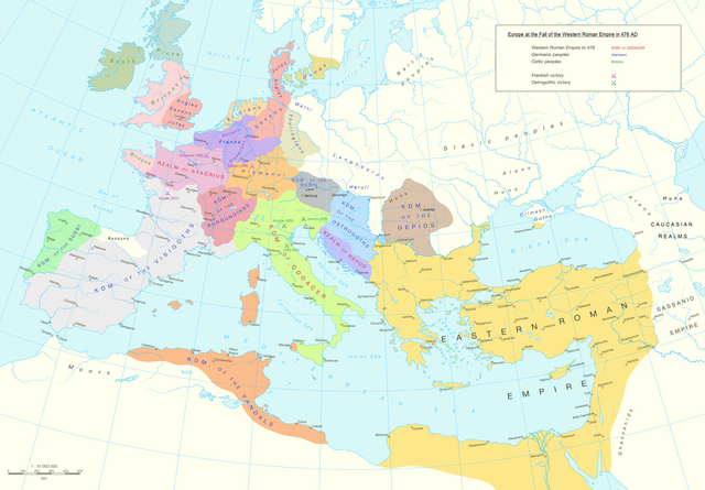
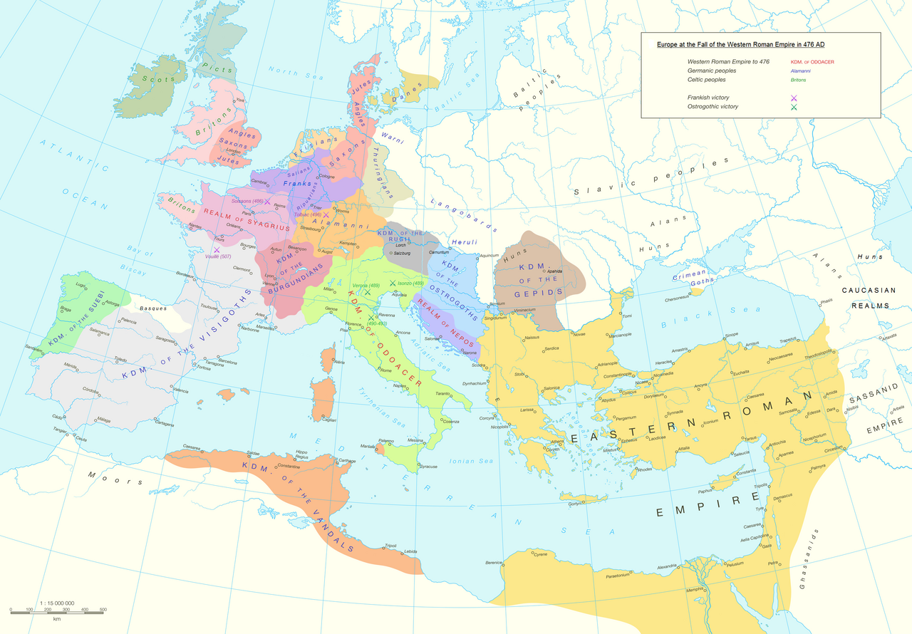
English: Political division in Europe, North Africa and Near East after the end of the Western Roman Empire in 476 AD. Romance area added since H. M. Glessegen (dir.), Handbuch der Romanische Sprachgeschichte, Berlin/New York, p. 544-555. Modified Gaëls / Picts / Britons (see discussion file).
Español: Mapa político de Europa, el Norte de África y Oriente Próximo tras el fin del Imperio Romano de Occidente en 476 d.C. Área románica añadida desde H. M. Glessegen (dir.), Handbuch der Romanische Sprachgeschichte, Berlín/Nueva York, p. 544-555. Gaëls / Pictos / Británicos modificados (ver archivo de discusión).
Français : L'Europe, l'Afrique du Nord et le Proche-Orient après la fin de l'Empire romain d'Occident en 476. Limites des langues romanes ajoutées d'après H. M. Glessegen (dir.), Handbuch der Romanische Sprachgeschichte, Berlin/New York, p. 544-555. Modifié les Gaëls / Pictes / Bretons d'après la page de discussion. |
| Data | |
| Sors | Putzger Historischer Weltatlas, Cornelsen, Berlin 1992 ISBN 3-464-00176-8, pp. 34-35 (maps by R. Hachmann). |
| Awtur | Guriezous |
| Permess (Użu mill-ġdid tal-fajl) |
Opra proprja |
Liċenzja
Jiena, id-detentur tal-copyright ta' dan ix-xogħol, niddikjara li se nippubblikah taħt il-liċenzja segwenti:
This file is licensed under the Creative Commons Attribution-Share Alike 4.0 International license.
- Inti ħieles:
- li taqsam – li tikkopja, tiddistribwixxi u tittrażmetti din l-opra
- li timmodifika – li tadatta l-biċċa xogħol
- Taħt il-kundizzjonijiet segwenti:
- attribuzzjoni – Għandek tattribwixxi x-xogħol bil-mod speċifikat mill-awtur jew minn min ta l-l-iċenzja (imma mhux b'xi mod li jissuġġerixxi ji jappoġjaw lilek jew l-użu tax-xogħol).
- Ixxerja bl-istess mod – Jekk tbiddel, tittrasforma jew tibni fuq dan il-materjal, inti għandek bżonn taqsam il-kontribuzzjonijiet tiegħek taħt l-istess liċenzja jew waħda li taqbel ma' dik oriġinali.
Kronoloġija tal-fajl
Agħfas fuq il-grupp data/ħin biex tara l-fajl biex tara kif jidher dak il-ħin.
| Data/Ħin | Minjatura | Qisien | Utent | Kumment | |
|---|---|---|---|---|---|
| kurrenti | 12:14, 5 Ottubru 2023 | | 2,830 × 1,967 (1.58 MB) | GPinkerton | Reverted to version as of 03:35, 9 January 2022 (UTC) this manipulation of maps is forbidden COM:CROP |
| 09:47, 24 Settembru 2023 |  | 2,830 × 1,967 (1.79 MB) | Claude Zygiel | Add details romance languages of the time according with the article "Romance languages" | |
| 16:52, 22 Settembru 2023 |  | 2,830 × 1,967 (1.78 MB) | Claude Zygiel | Gaëls. All germanic peoples colored. Romance area added since H. M. Glessegen (dir.), {{de}} ''Handbuch der Romanische Sprachgeschichte'', Berlin/New York, p. 544-555. | |
| 03:35, 9 Jannar 2022 |  | 2,830 × 1,967 (1.58 MB) | Jul059 | Lossless file size reduction | |
| 15:33, 7 Mejju 2016 |  | 2,830 × 1,967 (2.2 MB) | Guriezous | Eliminados nombres | |
| 20:08, 5 Mejju 2016 |  | 2,830 × 1,967 (2.21 MB) | Guriezous | Añadidos nombres. | |
| 17:43, 4 Mejju 2016 |  | 2,830 × 1,967 (2.2 MB) | Guriezous | Eliminados nombres rezagados. | |
| 08:52, 24 April 2016 |  | 2,830 × 1,967 (2.21 MB) | Guriezous | Eliminados nombres de provincias en gran parte aleatorias | |
| 10:12, 16 April 2016 |  | 2,830 × 1,967 (2.29 MB) | Guriezous | Eliminada Austrasia | |
| 10:11, 16 April 2016 |  | 2,830 × 1,967 (2.29 MB) | Guriezous | Eliminada Austrasia |
Użu tal-fajl
Il-Paġna segwenti twassal għal din l-istampa:
L-użu globali tal-fajl
Il-wikis segwenti jużaw dan il-fajl:
- Użu fuq ar.wikipedia.org
- Użu fuq ast.wikipedia.org
- Użu fuq azb.wikipedia.org
- Użu fuq bg.wikipedia.org
- Użu fuq bn.wikipedia.org
- Użu fuq ca.wikipedia.org
- Użu fuq cs.wikipedia.org
- Użu fuq de.wikipedia.org
- Użu fuq de.wikibooks.org
- Użu fuq de.wikiversity.org
- Użu fuq el.wikipedia.org
- Użu fuq en.wikipedia.org
- Alemanni
- Frisians
- Germanic peoples
- Middle Ages
- Marcomanni
- Ostrogoths
- Saxons
- Visigoths
- Vandals
- Rugii
- Thuringii
- Zeno (emperor)
- Migration Period
- Basiliscus
- Gepids
- Timeline of Jerusalem
- Campaign history of the Roman military
- Succession of the Roman Empire
- Fall of the Western Roman Empire
- French people
- Germanic kingship
Ara l-użu globali ta' dan il-fajl.