Stampa:Carte de l'Afrique-Occidentale française, 1914.svg

Size of this PNG preview of this SVG file: 661 × 599 pixels. Riżoluzzjonijiet oħra: 265 × 240 pixels | 529 × 480 pixels | 847 × 768 pixels | 1,129 × 1,024 pixels | 2,259 × 2,048 pixels | 868 × 787 pixels
Fajl oriġinali (Fajl fil-format SVG, dimensjoni nominali 868 × 787 pixel, dimensjoni tal-fajl: 1.7 MB)
| Dan huwa fajl mill-Wikimedia Commons. Il-deskrizzjoni fuq il-paġna ta' diskussjoni oriġinali tidher hawn taħt.
|
Taqsira
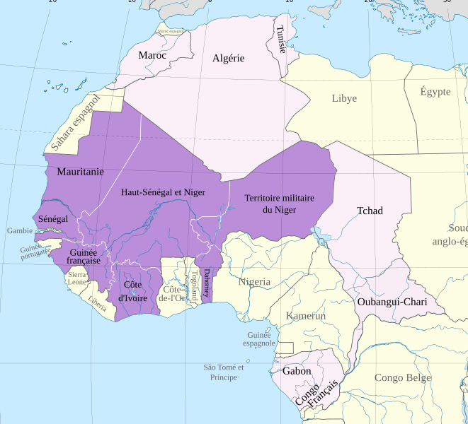
| Deskrizzjoni | Carte de l'Afrique-Occidentale française en l'an 1914 | ||
| Data | |||
| Sors | Africa map 1914.svg | ||
| Awtur | Hogweard | ||
| Permess (Użu mill-ġdid tal-fajl) |
|
Kronoloġija tal-fajl
Agħfas fuq il-grupp data/ħin biex tara l-fajl biex tara kif jidher dak il-ħin.
| Data/Ħin | Minjatura | Qisien | Utent | Kumment | |
|---|---|---|---|---|---|
| kurrenti | 00:01, 21 April 2024 | | 868 × 787 (1.7 MB) | GrandEscogriffe | corrections de langue |
| 23:02, 13 Diċembru 2023 |  | 868 × 787 (1.7 MB) | Hogweard | == {{int:filedesc}} == {{Information |Description=Carte de l'Afrique-Occidentale française en l'an 1914 |Source={{f|Africa map 1914.svg}} |Date=2023-12-12 |Author={{u|Hogweard}} |Permission={{PD-self}} |other_versions= }} Category:SVG maps showing history of Africa Category:Maps of 20th-century Africa Category:French-language SVG maps of Africa Category:Maps of French West Africa |
Użu tal-fajl
Il-Paġna segwenti twassal għal din l-istampa:
L-użu globali tal-fajl
Il-wikis segwenti jużaw dan il-fajl:
- Użu fuq ca.wikipedia.org
- Użu fuq en.wikipedia.org
- Użu fuq es.wikipedia.org
- Użu fuq fr.wikipedia.org
- Użu fuq pl.wikipedia.org
- Użu fuq ru.wikipedia.org
- Użu fuq www.wikidata.org