Stampa:Basin of Mexico 1519 map-es.svg

Size of this PNG preview of this SVG file: 449 × 599 pixels. Riżoluzzjonijiet oħra: 180 × 240 pixels | 360 × 480 pixels | 576 × 768 pixels | 768 × 1,024 pixels | 1,536 × 2,048 pixels | 1,412 × 1,883 pixels
Fajl oriġinali (Fajl fil-format SVG, dimensjoni nominali 1,412 × 1,883 pixel, dimensjoni tal-fajl: 526 KB)
| Dan huwa fajl mill-Wikimedia Commons. Il-deskrizzjoni fuq il-paġna ta' diskussjoni oriġinali tidher hawn taħt.
|
Taqsira
| Deskrizzjoni |
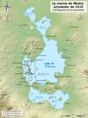
English: Map of the basin of Mexico circa 1519, at the arrival of the Spanish.
Español: Mapa de la cuenca de México en torno a 1519, a la llegada de los españoles
Français : Carte du bassin de Mexico vers 1519, à l'arrivée des Espagnols. |
| Data | 31 Jannar 2010, 09:03 (UTC) |
| Sors |
|
| Awtur |
|
| Verżjonijiet oħra |
[]
|
| SVG genesis |


| Camera location | | View this and other nearby images on: OpenStreetMap |
|---|
Liċenzja
Jiena, id-detentur tal-copyright ta' dan ix-xogħol, niddikjara li se nippubblikah taħt il-liċenzji segwenti:

|
Huwa permess li tikkopja, tiddistribwixxi u/jew timmodifika dan id-dokument abbażi tat-termini tal-Liċenzja ta' Dokumentazzjoni Ħielsa tal-GNU, Verżjoni 1.2 jew kwalunkwe verżjoni oħra pubblikata mill-Free Software Foundation; mingħajr ebda sezzjoni non-modifikabbli, mingħajr test tal-faċċata u mingħajr test tal-qoxra. Kopja tal-liċenzja hi inkluża fis-sezzjoni intitolata Test tal-Liċenzja ta' Dokumentazzjoni Ħielsa tal-GNU". |
This file is licensed under the Creative Commons Attribution-Share Alike 4.0 International, 3.0 Unported, 2.5 Generic, 2.0 Generic and 1.0 Generic license.
- Inti ħieles:
- li taqsam – li tikkopja, tiddistribwixxi u tittrażmetti din l-opra
- li timmodifika – li tadatta l-biċċa xogħol
- Taħt il-kundizzjonijiet segwenti:
- attribuzzjoni – Għandek tattribwixxi x-xogħol bil-mod speċifikat mill-awtur jew minn min ta l-l-iċenzja (imma mhux b'xi mod li jissuġġerixxi ji jappoġjaw lilek jew l-użu tax-xogħol).
- Ixxerja bl-istess mod – Jekk tbiddel, tittrasforma jew tibni fuq dan il-materjal, inti għandek bżonn taqsam il-kontribuzzjonijiet tiegħek taħt l-istess liċenzja jew waħda li taqbel ma' dik oriġinali.
Tista' tagħżel il-liċenzja li tippreferi.
Original upload log
This image is a derivative work of the following images:
- Lago de Texcoco-posclásico.png licensed with PD-self, PD-self/fr
- 2006-09-19T01:46:06Z Yavidaxiu 1412x1644 (344123 Bytes) {{Information |Description={{es|Mapa de la cuenca de México a la llegada de los españoles}} |Source=Trabajo propio |Date=18 de septiembre de 2006 |Author=Yavidaxiu |Permission={{PD-self}} |other_versions= }} [[Category:Map
- Valley of Mexico c.1519-fr.svg licensed with Cc-by-sa-2.5,2.0,1.0, Cc-by-sa-3.0-migrated, GFDL
- 2007-09-11T14:00:14Z Historicair 731x849 (270643 Bytes)
- 2007-09-11T13:51:30Z Historicair 731x849 (272818 Bytes) {{Information |Description={{fr|Les environs de Tenochtitlan vers 1519}} {{en|Valley of Mexico circa 1519}} |Source=Own work |Date=11/09/2007 |Author=~~~~ |Permission={{self2|GFDL|cc-by-sa-2.5,2.0,1.0}} |other_versions= }} {{
Uploaded with derivativeFX
Kronoloġija tal-fajl
Agħfas fuq il-grupp data/ħin biex tara l-fajl biex tara kif jidher dak il-ħin.
| Data/Ħin | Minjatura | Qisien | Utent | Kumment | |
|---|---|---|---|---|---|
| kurrenti | 20:56, 17 Jannar 2022 | | 1,412 × 1,883 (526 KB) | Sémhur | alrededor |
| 20:14, 4 Awwissu 2020 |  | 1,412 × 1,883 (526 KB) | Sémhur | Huexotla <=> Coatlinchán | |
| 18:32, 17 Lulju 2013 |  | 1,412 × 1,883 (524 KB) | Citypeek | Further enlargement of upper-right legenda. | |
| 18:11, 17 Lulju 2013 |  | 1,412 × 1,883 (525 KB) | Citypeek | Enlarged legenda in upper-right corner. | |
| 18:08, 17 Lulju 2013 |  | 1,412 × 1,883 (532 KB) | Citypeek | Corrected two errors. Valid SVG now. | |
| 11:10, 22 Frar 2010 |  | 1,412 × 1,883 (532 KB) | Sémhur | Orthograph | |
| 18:42, 8 Frar 2010 |  | 1,412 × 1,883 (532 KB) | Sémhur | + relief and some improvements | |
| 09:45, 31 Jannar 2010 |  | 1,412 × 1,644 (99 KB) | Sémhur | == {{int:filedesc}} == {{Information |Description= {{en|Map of the basin of Mexico circa 1519, at the arrival of the Spanish.}} {{es|Mapa de la cuenca de México acerca 1519, a la llegada de los españoles}} {{fr|Carte du bassin de Mexico vers 1519, à l |
Użu tal-fajl
Il-Paġna segwenti twassal għal din l-istampa:
L-użu globali tal-fajl
Il-wikis segwenti jużaw dan il-fajl:
- Użu fuq af.wikipedia.org
- Użu fuq ca.wikipedia.org
- Użu fuq cs.wikipedia.org
- Użu fuq de.wikipedia.org
- Użu fuq en.wikipedia.org
- Użu fuq eo.wikipedia.org
- Użu fuq es.wikipedia.org
- Użu fuq es.wikibooks.org
- Użu fuq gl.wikipedia.org
- Użu fuq hu.wikipedia.org
- Użu fuq it.wikipedia.org
- Użu fuq sv.wikipedia.org